
| 03472 252926 chairmankm@gmail.com |
Head Post Office Lane Krishnanagar, 741101 |
“About Krishnanagar Municipality”
“Serving citizens with transparency, efficiency, and dedication since 1864″
Krishnanagar is an age-old town having some distinctive features in respect of its historical and cultural background. The town Krishnanagar is the administrative HQ. of the district of Nadia in the state of West Bengal. It is situated at about 110 K. m. north of Kolkata by the side of N.H.-34 and is on the bank of River Jalangi.
Topographical/Geographical Parameters
Location
230 24` N Latitude and 880 31` E Longitude
Elevation
14 meters (on an average)
Area
15.96 Sq. Km.
Population
1,53,062(as per Census, 2011)
No. of wards
25
The town is situated on the flat terrain of the Gangetic West Bengal and the type of soil is alluvial. The difference of altitude of the highest and the lowest part of the town is not more than three feet. The climatic character is tropical by nature. The average yearly rainfall is about 1480 m. m. and the average humidity is about 75%. The highest temperature often attains 450 Celsius, while the lowest is about 7 to 80 Celsius.
Communication
Krishnanagar is well connected with Kolkata, the capital of the state with roads and railways. A broad gauge railway line and the NH-34 connecting Kolkata with Assam and adjoining states via North Bengal run just by the west of Krishnanagar town. The erstwhile narrow-gauge railway line linking Santipur and Nabadwip, the two places for pilgrimage of the Vaisnabas, were taken up for conversion into broad gauge. The line from Krishnagar to Santipur has already been converted and regular B.G. trains are plying, while the other is under the process of conversion. The town is also directly connected by road with Mayapur, the H.Q. of ISKCON in India.
Historical & Cultural Background
As per the historical information so far available, the ancestor of Maharaja Krishnachandra of Nadia district, started living in a village named ‘Reui’ after migrating from their the then residence at Matiara, Banpur situated at south-east of present Krishnagar. Maharaja Raghab, the grandson of Bhabananda Majumder (the first person of the Royal family), constructed a ‘Palace’ at Reui for their living. Afterwards, Maharaja Rudra Roy, the son of Maharaja Raghab named the place as ‘Krishnanagar’ as a mark of respect and reverence to Lord Krishna, while some persons believe that it was so named after the great annual Krishna-festival of the milkmen-community, the original residents of Reui.
However, in the mid-18th Century during the reign of Maharaja Krishnachandra, one of their successors in the 3rd or 4th generation and a contemporary of the then Nawab of Bengal Siraj-Ud-Doulya, the major developments in the field of Art, Culture & Literature took place. His royal court used to be graced by a galaxy of learned courtiers, some of them being well versed in Sanskrit literature. The great poet Bharat Chandra was his court-poet and during his tenure in the court Bharat Chandra composed the noted book of verse named ‘Annada Mangal’. In appreciation of his talent Maharaja awarded him the title of ‘Gunakar’. Another courtier was Sankar Taranga, who was brave, witty and an eloquent Speaker. However, the common belief of the existence of ‘Gopal Bhanr’ as the court-jester is not seconded by the historians. Such character might be an imaginary one, may be in resemblance of Sankar Taranga.
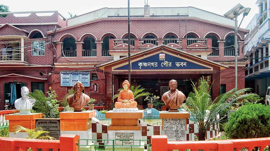
During these days, the literary and cultural environment started shining, which had, in fact, formed subsequently a cultural heritage. In fact, the tradition has flown during the 19th & 20th Century, as well. Dwijendra Lal Roy, a noted poet, dramatist and lyricist was born in this town in the year 1863 and this great son of the soil resorted to his strong pen in awakening patriotism in the country for freedom-struggle against the British rulers. Besides, the town is also the birth-place Ramtanu Lahiri, a noted educationist, who had in fact dedicated his life for reform and spread of education. This town has also been gratified with the glorious & memorable presence of great personalities like Pt. Iswar Chandra Vidyasagar, Rabindra Nath Thakur, Deshabandhu Chittaranjan Das, Sarojini Naidu, Kazi Nazrul Islam and also Subhas Chandra Bose.
At the humble invitation of Ramtanu Lahiri, Vidyasagar once graced the residence of Ramtanu Lahiri at Beledanga, Krishnagar with his kind presence. Rabindra Nath Thakur spent a few days at ‘Rani Kuthi’, Krishnagar. Deshabandhu Chittaranjan Das paid his kind visit in this town in connection with the electoral campaign in favour of Hemanta Kr. Sarkar, when he also visited the library founded by Ananta Hari Mitra, a freedom-fighter who was later put to death as a Martyr on 28th Sept., 1926. At the humble request of A. H. Mitra, Desabandhu named the library as ‘Sadhana Library’. Later, the Library was visited by Subhas Chandra Bose also, when he used to come to the residence of Hemanta kr. Sarkar, during 1923-’24. Sarojini Naidu paid her kind visit in this town, when she graced the Chair of the Chief Guest at the provincial conference of Indian National Congress held at Rajbari, Krishnagar in 1926 under the presidentship of Nirmal Chanda. Kazi Nazrul Islam stayed in this town for some days at the house named ‘Grace Cottage’, when he composed his famous poem ‘Kandari Hunsiar’.
Besides, the town is also proud of being the birth place of a galaxy of distinguished personalities like Ramtanu Lahiri, a noted educationist, who had in fact dedicated his life for reform and spread of education; Suresh Chandra Sarkar, the founder-editor of ‘Ananda Bazar Patrika’ and also ‘Hindusthan Standard’ and the weekly magazine ‘Desh’; Jagadananda Roy, a noted writer on Science-based subjects; Hemanta Kr. Sarkar, a great freedom-fighter & one of the closest disciples of Deshabandhu; Lalmohan Ghosh, a noted Barrister & one of the very senior organizers of Indian National Congress; Maharaja Khounish Chandra Roy, a great patroniser of Art, Culture & Education.
Moreover, the residents of this town had also been blessed to have witnessed closely the memorable activities of eminent persons like Pramatha Chowdhury, Kumud Nath Chowdhury, Jatindra Nath Mukhopadhyay (Bagha Jatin), Martyr Ananta Hari Mitra,Pandit Lakhsmikanta Moitra; Freedom-fighter Tarakdas Bandyopadhyay; Manmohan Ghosh, a great freedom-fighter, an eminent Barrister by profession, the first Press-Reporter of Nadia District, who had published the Fortnightly Journal ‘Indian Mirror’ in 1861 and at whose residence Michael Madhusudan had spent a few days; Brajanath Mukhopadhyay, an educationist & a dedicated Social Worker and founder of Krishnagar A.V. School: Azizul Haque and such others, who all had their respective sphere of activities in this town.
Another landmark in the field of Art & Craft, which was fostered under the direct patronage of the Art-lover Maharaja, is ‘clay models’. The artisans of this handicraft settled in the areas namely Sasthitala, Natunbazar Rathtala and Ghurni. The clay-models of ‘human-figures’ of Ghurni has earned a nation-wide fame for its highly skilled craftsmanship, while the sculptural work of Ghurni is renowned both in the country and the abroad. Ghurni is also the birthplace of Yogiraj Shri Shyama Charan Lahiri Mahasaya who was born on 30th September 1828 at Ghurni. He was an Indian Yogi and a disciple of Mahavatar Babaji. He revived the Yogic Science of Kriya Yoga.